


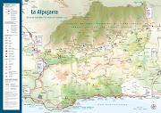
GR-142 Lanjarón-Órgiva
El sendero de gran recorrido GR-142, senda de la Alpujarra, incia su andadura en la llamada "Puerta de la Alpujarra", Lanjarón a unos 600m. de altitud. Pasa por la ermita de la Santa Cruz, por la Venta de los Herradores, el punto más alto de este tramo, a 875m.s.n.m., para finalizar en Órgiva, a la que llegamos después de cruzar el Río Chico. En Lanjarón hemos podido comprobar la profusión e importancia de sus fuentes mineromedicinales que han hecho de este lugar ser reconocido desde épocas romanas, y ser sede de una de las empresas de aguas más importantes de España. Sorprende,también que un pueblo cuyo termino municipal supera los 3000m. de altitud, con flora endémica de alta montaña pueda albergar en la parte baja cultivos subtropicales, como los aguacates. Y ... entramos en la Alpujarra.
Longitud: 7'1
Duración: 3 horas
Dificultad: Media


The GR-142 Alpujarra Route Long Distance Footpath begins in Lanjarón, which at and alitude of some 600 metres is often called the "Gateway to the Alpujarra". It passes by a hermitage called Emita de la Santa Cruz and a collection of country house called Venta de los Herradores, which mark the highest point of this section at and altitude of 875m, and endes in Órgiva, which you will reach after crossing the river there, the Río Chico. In Lanjarón you will notice the profusion and the importance of its various fontains of medicinal mineral water, which have map made this place famous since the Roman era, and it is at the centre of one of the most important water industry businesses in Spain. This town is remarkable not only because its municipal district rises above 3000 metres of altitude and for its associated high-moumtain endemic fauna, but also because in the lower areas it is sheltered anough for subtropical crops, such as avogados. What is more ... you have arrived in the Alpujarra.
Disntance: 7'1
Time: 3 hours
Difficulty: media
No hay comentarios:
Publicar un comentario